

It will show the likelihood of having higher indoor levels of the potentially harmful natural gas
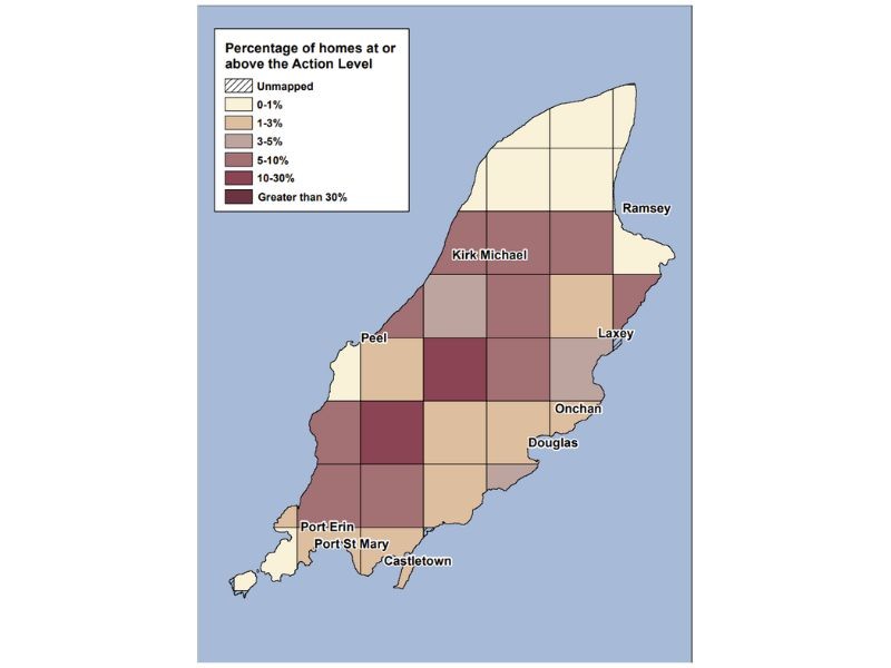
The Isle of Man has become the first Crown Dependency to be added to the radon risk map.
It shows where higher indoor levels of the naturally occurring gas are more likely.
It divides the Island into 35 areas, each covering around 25 km² (9.7 square miles), using data from more than 700 homes.
Darker colours indicate areas where a higher percentage of homes that are expected to reach or exceed the action level of 200 becquerels per cubic meter (Bq/m³).
Radon is a naturally occurring gas but it can cause lung cancer if exposed to high levels.
Tracy Gooding is the Principal Radiation Protection Scientist at the UK Health Security Agency (UKHSA):
Every building contains radon, but levels are usually low, and the likelihood of higher levels depends on the type of ground a property is built on.
Environment, Food and Agriculture Minister Claire Barber says: "The map is an important step in raising awareness across the Island.
"It gives households, employers, and public sector bodies the information they need to understand their risk and take action if necessary."
Homeowners in higher-risk areas are encouraged to test their property using radon kits, which monitor levels for a three month period.
Dr Matt Tyrer, Director of Public Health, adds: "Reducing radon exposure, particularly for people who smoke, is one of the most effective ways to lower lung cancer risk alongside stopping smoking."
The interactive map is available here.
You can listen to Tracy Gooding's interview in full below:
 Further two sailings cancelled
 Peel Commissioner at centre of row would 'welcome' external investigation
 Outdoor seating to be installed at Barbary Coast
 One year on: What's the latest for our Assisted Dying Bill?